Hiking in the Brooks is one of the few places on earth where one can still get a sense of what it was like to explore country as humans did in pre-map, pre-GPS, pre-Google Earth ages. Because there are few if any trails up here, hikers must read the landscape as much as maps.
This past week, my friend Josh Spice (not to be confused with my other friend named Josh) and I planned a two-day hike up Nutirwik Creek in the Central Brooks Range, just a few miles south of the treeline. We had plans of following drainages, climbing mountain passes, and hopping onto wide river valleys.
Our plans, though, fell apart within the first hour. You'll see why.
Here's a picture tour of our hike. (Most of these photos were taken by Josh--you can check out his outdoor adventure website here. He also sold me his Sony TX-5 for $150, so I'm happy I can once again take photos while I'm up here.)
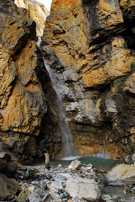
Here I am on Nutirwik Creek. We'd planned to walk up to the headwaters and over a mountain pass.

But from afar we could see that the creek narrowed considerably.

What to do now?

We wanted to continued to follow this creek since it led to the Chandalar River. So we needed to get around the waterfall. So we, uh, decided to climb the mountain to our left. (Which is a decision that didn't seem as stupid and badass as it looks in the pictures below.) Here I am climbing.
And here's Josh, who--an overly dedicated photographer, one could argue--refused to pack away his camera, forbidding himself the luxury of a second hand. "This is definitely 'sketch,'" he yelled to me as he carefully watched his purchase on the rocks.
Can you espy Josh?

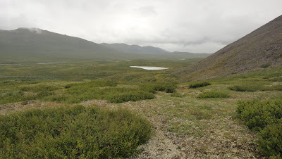
Finally, we made it a comfortable spot near the top. Some views of the Brooks Range.

We wanted to get back on the creek that had the waterfall, so we walked east on the side of the mountain on a Dall Sheep trail.
And then we realized that there is another, potentially impassible gorge that will prevent us from getting back on the creek.
We hike to the bottom of the gorge, hoping that we could reach the creek from boulder to boulder.
But then we came across yet another waterfall, except this time we were standing above it. With no other option, we climbed the mountain in front of us again.

Finally, we made it back onto the creek valley. This is called "Warm Water Creek" because there's a natural spring that shoots out 50 F degree water throughout the year.
Easy walking now. Weather got crappy, though, so here we are in our rain gear.

And finally we made it out to the Chandalar. This area is called Chandalar Shelf.

Josh is obsessed with ultra-light backpacking. (On the way, he gave me a 45-minute dissertation on the virtues of both down and synthetic sleeping bags. (It's a complex subject, supposedly, because by minute 40 I still had no idea which was better.)) His tent weighs something like a pound and it's held upright with his two trekking poles.


I was a little wary of sleeping it in because there's no bottom to the tent. I don't care too much about getting wet or cold, but I was reluctant because mosquitoes could get in through openings on the bottom. And sure enough, in the middle of the night, I woke up on several occasions, with two of them fat and plump on my nostril, needling their little probosces through my skin. Eventually, I had to don my bug hat for the rest of the night. Josh's face, when I looked over, was, curiously, left unperturbed.

The next day we walked to the road. Here we are walking on the pipeline, which, in parts, is underground. We walked 10 miles south on the Dalton Highway back to his vehicle and then drove back to Coldfoot, home sweet home.


4 comments:
Amazing scenery there! And wow, that was some climbing you were doing. Almost vertical and no ropes. That takes guts.
I only know of the Brooks Range from this blog, reading a bit about Ice Road Truckers and because of Carl McCunn. http://en.wikipedia.org/wiki/Carl_McCunn
Was your hike anywhere near where he camped?
Again, thanks heaps for your thoughrally interesting blog mate.
Awesome post, brother. Excellent synopsis of our adventurous exploration.
I'm inclined (no pun intended) to say that climbing such a steep slope without ropes or other equipment takes something other than guts: it takes a certain quality exemplified in the Redneck's Famous Last Words: "Watch this!" But I won't say that. Just glad you made it. Very good pictures.
Romana--I shouldn't be one to judge based on some of the pictures I just posted, but man, that guy made some questionable decisions... Seventy-five miles is not that far to walk, even through rigorous terrain... Plus, his failure to carefully schedule a way out was, well, just dumb.
But no, he really wasn't anywhere near where I am or was.
Josh--Thanks man, though I'm reluctant to use the word "adventurous" to describe a meager two-day hike mostly within sight of the road. Good times, nevertheless.
Anon--I hear ya, but I insist that that mountain didn't look that bad from below, or seem that bad when we were on it. When I look at some of those pictures I am truly amazed just how steep the mountain looks...
Post a Comment